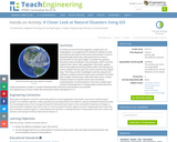
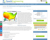
As if they are environmental engineers, student pairs are challenged to use …
As if they are environmental engineers, student pairs are challenged to use Google Earth Pro (free) GIS software to view and examine past data on hurricanes and tornados in order to (hypothetically) advise their state government on how to proceed with its next-year budget—to answer the question: should we reduce funding for natural disaster relief? To do this, students learn about maps, geographic information systems (GIS) and the global positioning system (GPS), and how they are used to deepen the way maps are used to examine and analyze data. Then they put their knowledge to work by using the GIS software to explore historical severe storm (tornado, hurricane) data in depth. Student pairs confer with other teams, conduct Internet research on specific storms and conclude by presenting their recommendations to the class. Students gain practice and perspective on making evidence-based decisions. A slide presentation as well as a student worksheet with instructions and questions are provided.
In this lesson, students find their location on a map using Latitude …
In this lesson, students find their location on a map using Latitude and Longitudinal coordinates. They determine where they should go to be rescued and how best to get there.
Students pass around and distort messages written on index cards to learn …
Students pass around and distort messages written on index cards to learn how we use signals from GPS occultations to study the atmosphere. The cards represent information sent from GPS satellites being distorted as they pass through different locations in the Earth's atmosphere and reach other satellites. Analyzing GPS occultations enables better global weather forecasting, storm tracking and climate change monitoring.
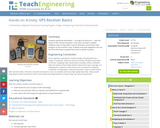
In this activity students will learn the basic concept of Global Positioning …
In this activity students will learn the basic concept of Global Positioning Systems (GPS) using triangulation and measurement on a small scale in the classroom. Students discover how GPS and navigation integrate mathematic and scientific concepts to create a standard for locating people and objects. This activity helps students understand both the need for and methods of navigation.
The concept of geocaching is introduced as a way for students to …
The concept of geocaching is introduced as a way for students to explore using a global positioning system (GPS) device and basic geographic information (GIS) skills. Students familiarize themselves with GPS, GIS, and geocaching as well as the concepts of latitude and longitude. They develop the skills and concepts needed to complete the associated activity while considering how these technologies relate to engineering. Students discuss images associated with GPS, watch a video on how GPS is used, and review a slide show of GIS basics. They estimate their location using latitude and longitude on a world map and watch a video that introduces the geocaching phenomenon. Finally, students practice using a GPS device to gain an understanding of the technology and how location and direction features work while sending and receiving data to a GIS such as Google Earth.
Students design their own logo or picture and use a handheld GPS …
Students design their own logo or picture and use a handheld GPS receiver to map it out. They write out a word or graphic on a field or playground, walk the path, and log GPS data. The results display their "art" on their GPS receiver screen.
Students familiarize themselves â through trial and error â with the basics …
Students familiarize themselves â through trial and error â with the basics of GPS receiver operation. They view a receiver's satellite visibility screen as they walk in various directions and monitor their progress on the receiver's map. Students may enter waypoints and use the GPS information to guide them back to specific locations.
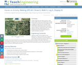
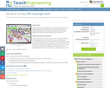
Students go on a GPS scavenger hunt. They use GPS receivers to …
Students go on a GPS scavenger hunt. They use GPS receivers to find designated waypoints and report back on what they found. They compute distances between waypoints based on the latitude and longitude, and compare with the distance the receiver finds.
During a scavenger hunt and an art project, students learn how to …
During a scavenger hunt and an art project, students learn how to use a handheld GPS receiver for personal navigation. Teachers can request assistance from the Institute of Navigation to find nearby members with experience in using GPS and in locating receivers to use.
Students take on the role of geographers and civil engineers and use …
Students take on the role of geographers and civil engineers and use a device enabled with the global positioning system (GPS) to locate geocache locations via a number of waypoints. Teams save their data points, upload them to geographic information systems (GIS) software, such as Google Earth, and create scale drawings of their explorations while solving problems of area, perimeter and rates. The activity is unique in its integration of technology for solving mathematical problems and asks students to relate GPS and GIS to engineering.
In past times, ocean navigators tossed a piece of wood over the …
In past times, ocean navigators tossed a piece of wood over the side of their ships and noted how long until the ship passed the wood. They used this time measurement and the length of the ship to calculate their speed and estimate how far they had traveled. In this activity, students act the part of a GPS signal traveling to the receiver to learn how travel time is converted to distance.
Students learn about the remote sensing radio occultation technique and how engineers …
Students learn about the remote sensing radio occultation technique and how engineers use it with GPS satellites to monitor and study the Earth's atmospheric activity. Students may be familiar with some everyday uses of GPS, but not as familiar with how GPS technology contributes to our ongoing need for great amounts of ever-changing global atmospheric data for accurate weather forecasting, storm tracking and climate change monitoring. GPS occultations are when GPS signals sent from one satellite to another are altered (delayed, refracted) by the atmosphere passed though, such that they can be analyzed to remotely learn about the planet's atmospheric conditions.
For thousands of years, navigators have looked to the sky for direction. …
For thousands of years, navigators have looked to the sky for direction. Today, celestial navigation has simply switched from using natural objects to human-created satellites. A constellation of satellites, called the Global Positioning System, and hand-held receivers allow for very accurate navigation. In this lesson, students investigate the fundamental concepts of GPS technology trilateration and using the speed of light to calculate distances.
In this unit, students learn the very basics of navigation, including the …
In this unit, students learn the very basics of navigation, including the different kinds of navigation and their purposes. The concepts of relative and absolute location, latitude, longitude and cardinal directions are explored, as well as the use and principles of maps and a compass. Students discover the history of navigation and learn the importance of math and how it ties into navigational techniques. Understanding how trilateration can determine one's location leads to a lesson on the global positioning system and how to use a GPS receiver. The unit concludes with an overview of orbits and spacecraft trajectories from Earth to other planets.
Projections and coordinates are key advancements in the geographic sciences that allow …
Projections and coordinates are key advancements in the geographic sciences that allow us to better understand the nature of the Earth and how to describe location. These innovations in describing the Earth are the basis for everything that is done in a GIS framework. Shape of the Earth is a critical starting point because in fact the Earth is not round but rather a more complex shape called a geoid. Coordinate systems are often referenced to a particular model shape of the Earth, but many different formats exist because not all coordinates work equally well in all areas. While projections and coordinates are abstract concepts in themselves, students eventually find them interesting because 1) it causes them to challenge their current ideas of the Earth's shape and 2) it is much easier to visualize these ideas for learning through interactive GIS such as Google Earth.
Students learn how and why engineers design satellites to benefit life on …
Students learn how and why engineers design satellites to benefit life on Earth, as well as explore motion, rockets and rocket motion. Through six lessons and 10 associated hands-on activities, students discover that the motion of all objects everything from the flight of a rocket to the movement of a canoe is governed by Newton's three laws of motion. This unit introduces students to the challenges of getting into space for the purpose of exploration. The ideas of thrust, weight and control are explored, helping students to fully understand what goes into the design of rockets and the value of understanding these scientific concepts. After learning how and why the experts make specific engineering choices, students also learn about the iterative engineering design process as they design and construct their own model rockets. Then students explore triangulation, a concept that is fundamental to the navigation of satellites and global positioning systems designed by engineers; by investigating these technologies, they learn how people can determine their positions and the locations of others.
To navigate, you must know roughly where you stand relative to your …
To navigate, you must know roughly where you stand relative to your designation, so you can head in the right direction. In locations where landmarks are not available to help navigate (in deserts, on seas), objects in the sky are the only reference points. While celestial objects move fairly predictably, and rough longitude is not too difficult to find, it is not a simple matter to determine latitude and precise positions. In this activity, students investigate the uses and advantages of modern GPS for navigation.
Geographic information systems (GIS) are important technology that allows rapid study and …
Geographic information systems (GIS) are important technology that allows rapid study and use of spatial information. GIS have become increasingly prevalent in industry and the consumer/internet world in the last 20 years. Historically, the basis of GIS was in mapping, and so it is important to understand the basis of maps and how to use them as well as why they are different from GIS. In this lesson, students learn the value of maps, how to use maps, and the basic components of a GIS. They are also introduced to numerous GIS applications.
How do we know where we are? What happens if you are …
How do we know where we are? What happens if you are completely lost in the middle of nowhere? Does technology provide tools for people lost in their travels? A person cannot usually determine an accurate position just by looking out a window in the middle of the ocean or vast area of land, particularly if it has not been charted before. In this lesson, students explore the concept of triangulation that is used in navigation satellites and global positioning systems designed by engineers. Also, students learn how these technologies can help people determine their position or the location of someone else.
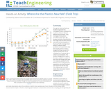
Through an adult-led field trip, students organized into investigation teams catalogue the …
Through an adult-led field trip, students organized into investigation teams catalogue the incidence of plastic debris in different environments. They investigate these plastics according to their type, age, location and other characteristics that might indicate what potential they have for becoming part of the Great Pacific Garbage Patch (GPGP). Students collect qualitative and quantitative data that may be used to create a Google Earth layer as part of a separate activity that can be completed at a computer lab at school or as homework. The activity is designed as a step on the way to student's creation of their own GIS Google Earth layer. It is, however, possible for the field trip to be a useful learning experience unto itself that does not require this last GIS step.
No restrictions on your remixing, redistributing, or making derivative works. Give credit to the author, as required.
Your remixing, redistributing, or making derivatives works comes with some restrictions, including how it is shared.
Your redistributing comes with some restrictions. Do not remix or make derivative works.
Most restrictive license type. Prohibits most uses, sharing, and any changes.
Copyrighted materials, available under Fair Use and the TEACH Act for US-based educators, or other custom arrangements. Go to the resource provider to see their individual restrictions.