Finding themselves in the middle of the Amazon rainforest after a plane …
Finding themselves in the middle of the Amazon rainforest after a plane crash, students use map scales, keys, and longitude and latitude coordinates to figure out where they are. Then they work in groups to generate ideas and make plans. They decide where they should go to be rescued, the distance to that location, the route to take, and make calculations to estimate walking travel time.
Students create models of objects of their choice, giving them skills and …
Students create models of objects of their choice, giving them skills and practice in techniques used by professionals. They make sketches as they build their objects. This activity facilitates a discussion on models and their usefulness.
Students build miniature model cities using sugar, bouillon and gelatin cubes. The …
Students build miniature model cities using sugar, bouillon and gelatin cubes. The cities are put through simulated earthquakes to see which cube structures withstand the shaking movements the best.
In this lesson, students find their location on a map using Latitude …
In this lesson, students find their location on a map using Latitude and Longitudinal coordinates. They determine where they should go to be rescued and how best to get there.
Students design and build a model city powered by the sun! They …
Students design and build a model city powered by the sun! They learn about the benefits of solar power, and how architectural and building engineers integrate photovoltaic panels into the design of buildings.
How can an understanding of pH—a logarithmic scale used to identify the …
How can an understanding of pH—a logarithmic scale used to identify the acidity or basicity of a water-based solution—be used to design and create a color-changing paint? This activity provides students the opportunity to extract dyes from natural products and test dyes for acids or bases as teams develop a prototype “paint” that is eventually applied to help with a wall redesign at a local children’s hospital. Students learn about how dyes are extracted from organic material and use the engineering design process to test dyes using a variety of indicators to achieve the right color for their prototype. Students iterate on their dyes and use ratios and proportions to calculate the amount of dye needed to successfully complete their painting project.
Students are introduced to detail drawings and the importance of clearly documenting …
Students are introduced to detail drawings and the importance of clearly documenting and communicating their designs. They are introduced to the American National Standards Institute (ANSI) Y14.5 standard, which controls how engineers communicate and archive design information. They are introduced to standard paper sizes and drawing view conventions, which are major components of the Y14.5 standard.
To evaluate the different integumentary systems found in the animal kingdom, students …
To evaluate the different integumentary systems found in the animal kingdom, students conduct an exploratory research-based lab. During the activity, students create a model epidermis that contains phosphorescent powder and compare the results to a control model. After learning about the variations of integumentary systems—systems that comprise the skin and other appendages that act to protect animal bodies from damage—students act as engineers to mimic animal skin samples. Their goal is to create a skin sample that closely represents the animal they are mimicking while protecting the base ‘epidermis’ from UV light.
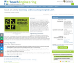
Students take on the role of geographers and civil engineers and use …
Students take on the role of geographers and civil engineers and use a device enabled with the global positioning system (GPS) to locate geocache locations via a number of waypoints. Teams save their data points, upload them to geographic information systems (GIS) software, such as Google Earth, and create scale drawings of their explorations while solving problems of area, perimeter and rates. The activity is unique in its integration of technology for solving mathematical problems and asks students to relate GPS and GIS to engineering.
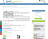
In this lesson, students learn how to determine location by triangulation. We …
In this lesson, students learn how to determine location by triangulation. We describe the process of triangulation and practice finding your location on a worksheet, in the classroom, and outdoors.
In this 30-day Grade 7 module, students build upon sixth grade reasoning …
In this 30-day Grade 7 module, students build upon sixth grade reasoning of ratios and rates to formally define proportional relationships and the constant of proportionality. Students explore multiple representations of proportional relationships by looking at tables, graphs, equations, and verbal descriptions. Students extend their understanding about ratios and proportional relationships to compute unit rates for ratios and rates specified by rational numbers. The module concludes with students applying proportional reasoning to identify scale factor and create a scale drawing.
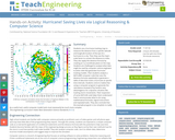
Students use a hurricane tracking map to measure the distance from a …
Students use a hurricane tracking map to measure the distance from a specific latitude and longitude location of the eye of a hurricane to a city. Then they use the map's scale factor to convert the distance to miles. They also apply the distance formula by creating an x-y coordinate plane on the map. Students are challenged to analyze what data might be used by computer science engineers to write code that generates hurricane tracking models. Then students analyze a MATLAB® computer code that uses the distance formula repetitively to generate a table of data that tracks a hurricane at specific time intervals. Students come to realize that using a computer program to generate the calculations (instead of by hand) is very advantageous for a dynamic situation like tracking storm movements. Their inspection of some MATLAB code helps them understand how it communicates what to do using mathematical formulas, logical instructions and repeated tasks. They also conclude that the example program is too simplistic to really be a useful tool; useful computer model tools must necessarily be much more complex.
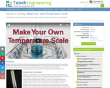
Students learn about the difference between temperature and thermal energy. They build …
Students learn about the difference between temperature and thermal energy. They build a thermometer using simple materials and develop their own scale for measuring temperature. They compare their thermometer to a commercial thermometer, and get a sense for why engineers need to understand the properties of thermal energy.
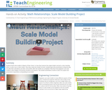
Students build scale models of objects of their choice. In class they …
Students build scale models of objects of their choice. In class they measure the original object and pick a scale, deciding either to scale it up or scale it down. Then they create the models at home. Students give two presentations along the way, one after their calculations are done, and another after the models are completed. They learn how engineers use scale models in their designs of structures, products and systems. Two student worksheets as well as rubrics for project and presentation expectations and grading are provided.
Students learn how different characteristics of shapes—side lengths, perimeter and area—change when …
Students learn how different characteristics of shapes—side lengths, perimeter and area—change when the shapes are scaled, either enlarged or reduced. Student pairs conduct a “scaling investigation” to measure and calculate shape dimensions (rectangle, quarter circle, triangle; lengths, perimeters, areas) from a bedroom floorplan provided at three scales. They analyze their data to notice the mathematical relationships that hold true during the scaling process. They see how this can be useful in real-world situations like when engineers design wearable or implantable biosensors. This prepares students for the associated activity in which they use this knowledge to help them reduce or enlarge their drawings as part of the process of designing their own wearables products. Pre/post-activity quizzes, a worksheet and wrap-up concepts handout are provided.
Students learn how to determine map distances and areas using the map …
Students learn how to determine map distances and areas using the map scale. They get a feel for how much an area represents on the map in relation to the size they are suggesting for their underground caverns to shelter the Alabraska population.
Students are introduced to the concepts of graywater and water reuse within …
Students are introduced to the concepts of graywater and water reuse within households. They calculate the amount of used water a family generates in one day and use a model of home plumbing to find out how much graywater is produced in homes every day. They graph their results and discuss energy efficiency implications. Students are then challenged to find ways to reduce water use within the home.
Students learn about contact stress and its applications in engineering. They are …
Students learn about contact stress and its applications in engineering. They are introduced to the concept of heavy loads, such as buildings, elephants, people and traffic, and learn how those heavy loads apply contact stress. Through the analysis of their own footprints, students determine their contact stress.
Maps are designed to allow people to travel to a new location …
Maps are designed to allow people to travel to a new location without a guide to show the way. They tell us information about areas to which we may or may not have ever been. There are many types of maps available for both recreational and professional use. A navigator uses a nautical map, while an engineer might use a surveyor's map. Maps are created by cartographers, and they can be very specific or very general, depending on their intended use. The focus of this lesson is on how to read and use topographical maps. Students will also learn to identify the common features of a map. Through the associated activities, students will learn how to use a compass to find bearing to an object on a map and in the classroom.
No restrictions on your remixing, redistributing, or making derivative works. Give credit to the author, as required.
Your remixing, redistributing, or making derivatives works comes with some restrictions, including how it is shared.
Your redistributing comes with some restrictions. Do not remix or make derivative works.
Most restrictive license type. Prohibits most uses, sharing, and any changes.
Copyrighted materials, available under Fair Use and the TEACH Act for US-based educators, or other custom arrangements. Go to the resource provider to see their individual restrictions.